Ling
 |
| Maps: |


|
| USGS 7.5' Map: |
Alma |
| Statistics: |
| Difficulty: |
Number: |
Miles: |
Altitude: |
Obstacles: |
Time: |
| Easy 2 |
FR 437 |
3.80 |
11,539 to 12,200 ft. |
Ledge Road - 1 |
1-2 hours |
|
| County: |
Park |
| Adopted by: |
|
|
|
| Managed by: |
Pike National Forest
South Park Ranger District
|
320 Hwy 285, P.O. Box 219
Fairplay, CO 80440 |
(719)836-2031
|
| Summary: |
|
| Attractions: |
Scenery, Mines |
Seasonal
Closure |
|
| Best Time: |
June - Probably still snowed in
July - Best late in the month
August - Best
September - Best |
Trail Heads
Accessed: |
|
| Camping: |
There are a few dispersed campsites just past the Hoosier Pass parking area |
| Base Camp: |
This would be a good place to base camp to explore the hiking trails to North Star Mountain, Clinton Peak and Hoosier Ridge |
| Fall Colors: |
Poor - Above timberline |
| Navigation: |
From Breckenridge CO. head south on S Main St toward W Adams Ave for 0.3 miles. Turn left onto CO-9 S/S Main St and continue to follow CO-9 S for 9.9 miles. Turn right into the Hoosier Pass parking lot and continue on FR2 at the north end of the lot. This is the Ling 4WD road.
From Fairplay, CO. head northwest on CO-9 N/Main Street toward 4th Street and continue to follow CO-9 N for 11.8 miles. Turn left into the Hoosier Pass parking lot and continue on FR2 at the north end of the lot. This is the Ling 4WD road. |
| History: |
The Ling 4WD road was created to access the Ling Mine on the south side of North Star Mountain.
|
| Description: |
The Ling 4WD road is a short road that takes off to the west of Hoosier Pass. It leaves from the north end of the large parking area on the pass near the main sign. The road will head through the trees passing a few camp spots. Just past the trees the road will climb a bit around some ruts and pot holes and become more of a ledge road on the south side of North Star Mountain. Though a ledge road it stays fairly wide. On an east facing curve in the road you may run into a snow drift that may block the road into the early summer.
Past this area the road continues around a hill and comes into a wide saddle where there are some mine remains and a locked gate blocking travel further west. From the saddle their is a road that climbs to the top of the rounded hill to the east.
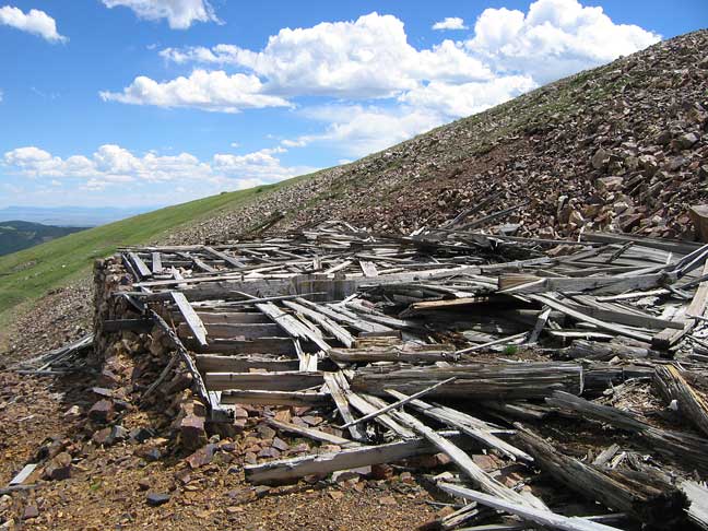 |
Mine remains at the end of the road
photo by:
Adam M |
The old road bed continues past the private property gate for about 0.4 miles to the remains of the Magnolia Mine. The Magnolia Mine is where the aerial tram from the Magnolia Mill goes to. There is not much left of the mine. After another 1 mile the old road ends at the Ling Mine site. The mine can be seen up on the ridge at 12,300 feet from the Wheeler Lake 4WD road down in the valley below.
|
|
|
Data updated - December 26, 2014
4WD Road driven - July 21, 2014
Copyright 4X4Explore - 2000-2015 |

