Hancock
Pass  |
| Maps/GPS: |


|
| USGS 7.5' Map: |
Saint Elmo, Garfield, Whitepine |
| Statistics: |
| Difficulty: |
Number: |
Miles: |
Altitude: |
Obstacles: |
Time: |
| Moderate - 5 |
FR299, FR266 |
3.0 |
11,040 - 12,160 ft. |
NA |
1-2 hours |
|
| County: |
Chaffee, Gunnison |
| Adopted by: |
|
|
|
| Managed by: |
Pike/San Isabel National Forest
Salida Ranger District
Grand Mesa/Uncompahgre/Gunnison National Forest
Gunnison Ranger District |
325 West Rainbow Blvd.
Salida, CO 81201
216 N. Colorado
Gunnison, CO 81230 |
719-539-3591
970-641-0471 |
| Summary: |
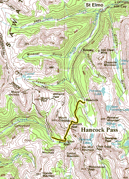
The Hancock Pass 4WD road runs from the ghost town of Hancock to Brittle Silver Basin. The road is narrow and climbs above timberline fairly quickly.
|
| Attractions: |
Mountain pass, Scenery, History
|
Seasonal
Closure: |
Natural - The Hancock Pass 4WD road is closed by snow each season.
|
| Best Time: |
June - The upper part is usually still closed by snow
July - Possible opening depending on snow
August - Best
September - Best
October - Early in the month |
Trail Heads
Accessed: |
Continental Divide Trail
Trail to Alpine Tunnel
|
| Camping: |
There are no dispersed sites along Hancock Pass. The upper section is very exposed.
|
| Base Camp: |
This would be a good area to base camp with the large number of 4WD roads including Tomichi Pass, Pomeroy Lake, Tin Cup Pass, and Cumberland Pass.
|
| Fall Colors: |
Good - The fall
colors in the surrounding valleys with the high mountain peaks makes for nice photos.
|
| Navigation: |
From Buena Vist, CO head south on US Hwy 24 for 7 miles. Turn right onto Chalk Creek Drive/Cnty Road 162 and go 15.4 miles to Forest Service road 295. Turn left onto FR295 and go 5.5 miles to the ghost town of Hancock. Stay left at the intersection and then turn onto Forest Service road 299, Hancock Pass road.
From Pitkin, CO head northeast on Main Street for 0.4 miles. Turn left onto State Street and continue on Cnty Road 76 for 0.7 miles. Continue on Forest Service road 765 for 2.0 miles. Make a sharp right turn onto Forest Service road 839. Go 8.2 miles to a hairpin turn and continue straight onto FR888. Go 0.5 miles on FR888 to the head of Brittle Silver Basin. Just before reaching a hairpin turn in the valley that heads to Tomichi Pass, take a left onto the Hancock Pass road.
|
| History: |
Regular use of Hancock Pass began around 1888 related to mining in the area. It became officially named in 1962.
|
| Description: |
Hancock Pass crosses the Continental Divide and divides Chalk Creek to the north and Middle Quartz Creek to the South. Hancock Pass 4WD road is a short climb to the pass between Mount Chapman and Van Wirt Mountain. It starts in the ghost town of Hancock and works up through the forest along a short valley as you climb above treeline. There is one long switchback to climb out of the valley and up onto a bench that leads to the pass. The southwest side of the pass descends quickly down to the Brittle Silver Basin at the head of Middle Quartz Creek.
 |
East side of Hancock Pass (just in the trees)
photo by:
Adam M |
 |
East side of Hancock Pass climb to the top
photo by:
Adam M |
 |
Hancock Pass
photo by:
Adam M |
 |
Brittle Silver Basin, center of picture. Tomichi Pass
left of the trees.
photo by:
Adam M |
 |
Hancock Pass (west side) from Tomichi Pass
photo by:
Adam M |
|
|
Data updated - November 1, 2022
4WD Road driven - September 4, 2011
Copyright 4X4Explore.com - 2000-2011 |