Mt Zion  |
| Maps: |


|
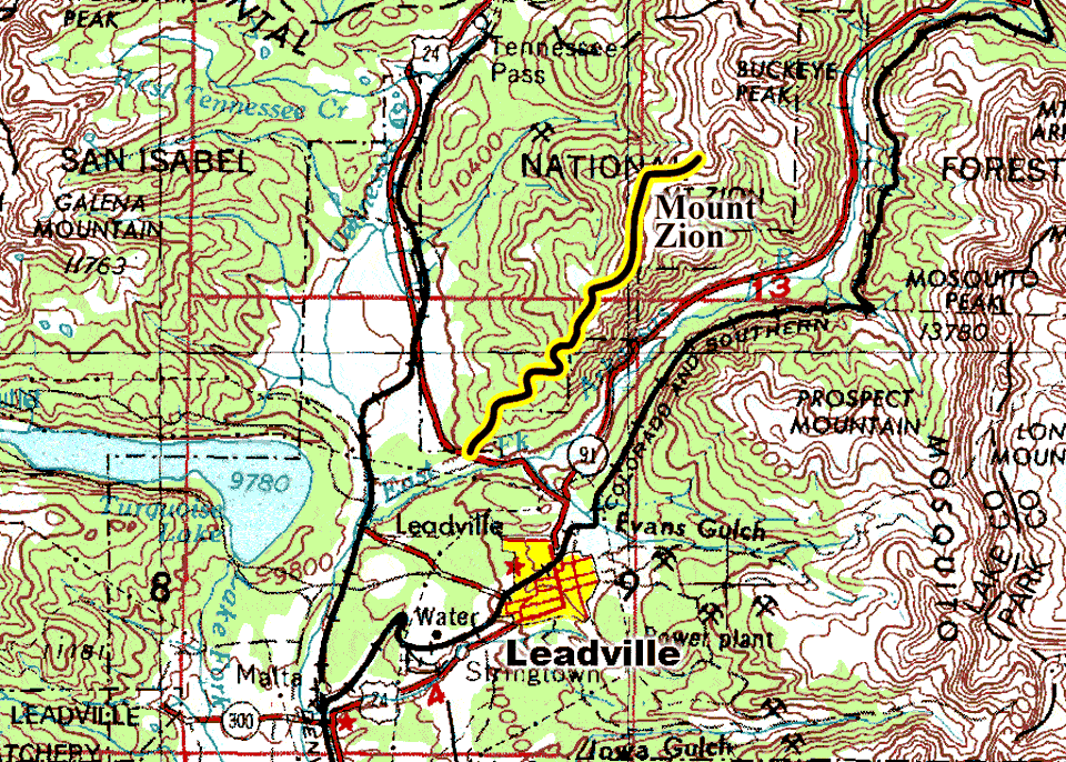
| USGS 7.5' Map: |
Leadville North |
| Statistics: |
| Difficulty: |
Number: |
Miles: |
Altitude: |
Obstacles: |
Time: |
| Easy 3 |
FR 109 |
5.60 |
9,950 to 12,090 ft. |
Steep Hill |
2-3 hours |
|
| County: |
Lake |
| Adopted by: |
|
|
|
| Managed by: |
San Isabel National Forest,
Leadville Ranger District |
810 Front Street
Leadville, CO 80461 |
719-486-0749 |
| Summary: |
Mt Zion 4WD road climbs close to the top of Mt Zion and crosses the tundra over to its end below Buckeye Peak. |
| Attractions: |
Scenery |
Seasonal
Closure: |
Natural - Closed by heavy snows. |
| Best Time: |
June- May still be snow in the trees
July - Best
August - Best
September - Best
October - Early snows may block the road |
Trail Heads
Accessed: |
Buckeye Peak is in striking distance from the road end. (No official Trail) |
| Camping: |
There are dispersed campsites at the start of the Mt Zion road. |
| Base Camp: |
This would be a good area to base camp and explore the roads around Leadville. |
| Fall Colors: |
Poor - There are a few aspen at the start, but the main forest is pine. |
| Navigation: |
From Leadville, CO head north on Harrison Ave toward W 6th Street for 0.2 miles. Turn right onto E 9th Street and go 0.1 miles. Turn left and go 1.0 mile. Turn left onto US-24 West and go 1.4 miles. Turn right onto Trail Road. This is the start of Mt Zion 4WD road.
|
| History: |
|
| Description: |
Mt Zion starts out right off of Hwy 24. At the turn off is a small parking area followed by a larger parking area. Just past the larger parking area is a road to the right, Trail Road, that goes a short distance to the east and ends. The second right is another very short spur that ties into Trail Road. The next two right turns are part of a loop that goes into the trees to some dispersed campsites. After you go into the trees a short disance from the camping loop you will come to another right turn that also dead ends. Staying to the left through this section will keep you on the Mt Zion road. After the last intersection the road will climb a hill and begin its climb into the forest. The road will be a two track through the trees. After three quarters of a mile from the last intersection you will come out into some small meadows in the forest.
 |
Lower section
photo by:
Adam M |
The road will head back into more trees as it continues its climb. The next intersection is with No Name, FR189, road on the left. Stay to the right and continue climbing. The road will continue through the trees and then come out into another larger meadow. At the top of the meadow will be a bare ridge. To reach the top of the ridge the road will climb a last very steep section, that is the only real challenge, make a left turn and come to an T intersection.
 |
Top of steep climb. Turquoise Lake in background.
photo by:
Adam M |
The road to the left from the T goes to some communication towers. Stay to the right. From hear you can look back down toward Turquoise Lake. The trees will start to thin as you continue.
 |
Heading toward timberline
photo by:
Adam M |
You will climb a wide ridge and get above timberline where you will have views in all directions. This is close to the top of Mt Zion, near 12,120 feet in altitude.
 |
Top of Mt Zion looking north
photo by:
Adam M |
The road will head across the wide ridge and down into a shallow dip before climbing up and over another wide ridge. The road will cross a saddle and go a short distance to its end below some false peaks below Buckeye Peak.
 |
Looking back from road end, Mt. Zion in the upper left
photo by:
Adam M |
 |
Heading back down to the trees
photo by:
Adam M |
|
|
Data updated - December 23, 2020
4WD Road driven - September 5, 2020
Copyright 4X4Explore.com - 2000-2021 |