North Hunt Creek
 |
| Maps/GPS: |


|
| USGS 7.5' Map: |
Sand Point |
| Statistics: |
| Difficulty: |
Number: |
Miles: |
Altitude: |
Obstacles: |
Time: |
| Easy 1 |
FR 936 |
0.30 |
8,620 ft. |
NA |
1/2 hour |
|
| County: |
Rio Blanco |
| Adopted by: |
|
|
|
| Managed by: |
Routt National Forest,
Yampa Ranger District |
300 Roselawn Ave (PO Box 7)
Yampa, Colorado 80483 |
(970)638-4516 |
| Summary: |
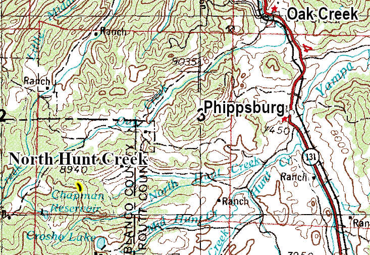
North Hunt Creek is a very short spur road off of County Road 8, the Dunkley Pass road, that goes to a large flat parking area used for camping. |
|
| Attractions: |
Forest Access |
Seasonal
Closure: |
Natural - Closed by heavy snows.
|
| Best Time: |
June - Possible snow drifts
July - Best
August - Best
September - Best
October - Early snows possible |
Trail Heads
Accessed: |
There is a trail that follows the old road south to North Hunt Creek. |
| Camping: |
There is one large dispersed site at the end of the road. |
| Base Camp: |
This would be a good site for a base camp. Other base camp sites are along the Dunkley Pass road. |
| Fall Colors: |
Very Good - Lots of aspen along the road.
|
| Navigation: |
From Oak Creek Colorado head west toward Moffat Ave and go 0.3 miles. Turn left onto South Bell Ave and go 0.3 miles. Turn right onto County Road 25 and go 6.2 miles. Turn left onto Forest Road 925 and go 1.4 miles. Continue on Rcr132/County Road 8 for 2.0 miles. Turn left onto North Hunt Creek road.
From Yampa Colorado head north on Colorado State Highway 131 for 5.4 miles. Turn left onto Rcr15 and go 174 feet. Rcr15 turns slightly right and becomes County Road 15, go 0.6 miles. County Road 15 turns left and becomes Rcr15, go 0.3 miles. Turn right onto Rcr19 and go 0.8 miles. Slight right to stay on Rcr 19 and go 0.5 miles. Continue onto County Road 19 and go 4.3 miles. Continue on County Road 8 for 1.4 miles. Turn left onto North Hunt Creek road.
|
| History: |
|
| Description: |
The North Hunt Creek road is a very short easy spur road that ends at a large flat parking area that is used for camping and as access to a trail to North Hunt Creek. The road is a wide and maintained such that camping trailers can use the road. The road ends in a large graveled turn around that is used for camping. From the south end of the turn around there is a casual trail the heads south following the old road that went to North Hunt Creek 1.65 miles away. The forest surrounding the turn around is mainly aspen.
|
|
Data updated - February 15, 2026
4WD Road driven - July 27, 2025
Copyright 4X4Explore.com - 2000-2026 |