

| Difficulty: | Number: | Miles: | Altitude: | Obstacles: | Time: |
|---|---|---|---|---|---|
| 2 | FR240 | 7.97 | 9.160 to 12,000 ft. | NA | 3-4 hours |
Closure:
July - Best
August - Best
September - Best
October - Early snows possible
Mount Shavano, FT1428 - Hike, Horseback, Mountain Bike
Island Lake - Hike
Jennings Creek Trailhead - Hike
From Poncha Springs head north on US Hwy 285 N toward Poncha Avenue for 0.6 miles. Continue onto US-50 W for 6.3 miles. Turn right onto County Road 240 and go 3.8 miles. County Road 240 changes to FR240.
 |
|---|
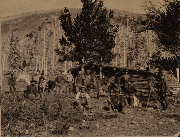
| A group of miners at the townsite of Shavano, approximately 1882. Image from Dr. Howard Smith, son of Mr. and Mrs. George Smith. The teenager at left of cabin is George Smith. This image is part of the Donna Nevens Collection. |
Beyond Shavano at the headwaters of the North Fork of the South Arkansas River is the site of the Billings Tunnel mine above small Billings Lake. This mine is below Pomeroy Mountain and has a large cut stone entrance and is now known as the Pride of the West Mine today. With all the expense of the entrance, the mine was not profitable in the end.
A short rebirth of the area happened on New Years day in 1904 when Judge J.H. Akin of Shavano and E.W. Carpenter of Salida discovered silver high in the mountains near the Chaffee County and Gunnison County line above the Pride of the West Mine. They had climbed the range on snowshoes and saw some float. After digging through three fee of snow, they drove stakes and claimed the Netsie Castley claim. From the four foot vein they hacked out a 200 pound piece of ore. From this they took a sample to be assayed. It contained 119 ounces of silver, and $3.50 in gold to the ton. The mine was between the Mary Murphy mine to the north and the Madonna mine to the south.
Jessen, Kenneth Ghost Towns Colorado Style, Volumn 2, 1st ed. Loveland, Colorado: J.V. Publications, 1999. Print.
Eberhart, Perry Guide to Colorado Ghost Towns and Mining Camps, 4th ed. Athens, Ohio: Swallow Press, 1974. Print.
Wolle, Muriel Sibell Stampede to Timberline, 2nd ed. Athens, Ohio: Swallow Press, 1974. Print.
The road will cross over the river again and head away from the river. After a short distance you will come out into a small open area before heading back into the trees. To the north will be Mount Shavano. The road will head back toward the river and cross McCoy Creek on your right coming off of Tabeguache Peak. You will come into some aspen groves and then an open area. There will be a short spur loop to your left that goes to a campsite by the river. You will head back into the trees following the river as it widens out to form a marshy areas. Shortly the landscape will tighten up narrowing the river channel. There will be a waterfall in the river near here.
Continuing you will pass through some small open areas. The road will now head west and pass along another wide area where the river spreads out forming large marshy ponds. You will pass through some aspen here and then cross through some brush that tightens the road corridor. After heading back into the forest you will come to a small parking area on the right side of the road for the Jennings Creek Trail. There will be another brushy area to drive through past the trailhead before you get back into the forest. The road will now head straight for a while passing a spur to the left that has a gate on it. Past this spur is where the town of Shavano once stood. Next you will pass a small pull off on your right and then further along where the forest starts to thin out you will pass a campsite on the left.
The forest will thin out a bit more as you pass another area where the river widens out into small ponds. Next you will climb away from the river and do two switchbacks. The road will now pass through forested and small open areas. You will come to an intersection. The road to the left goes to the North Fork Reservoir Campground. The road to the right will continue to climb up toward the cirque between Pomeroy and Calico Mountains. Past the intersection you will pass a spur road to the left that goes to a campsite. Continuing on the main road you will climb up and out of the forest giving you views of the head of the valley. Next you will come to a small parking area where a trail following an old road heads over to an intersection. If you hike the trail a left at that intersection will follow a trail to Island Lake, above North Fork Reservoir. Continuing on the main road you will come to another intersection. The road to the left heads down to Billings Lake. Staying to the right will continue the climb around and above Billings lake bringing you to a parking area near the Pride of the West Mine, which has a unique stone mine portal. This is the end of the road. Return the way you came.